ENVIRONMENT | By Jeff Kuyper, Executive Director Los Padres Forest Watch
Local Trails, Schools and Conservation Lands To Be Opened For Fracking
BLM Accepting Public Comments Until Sept. 7
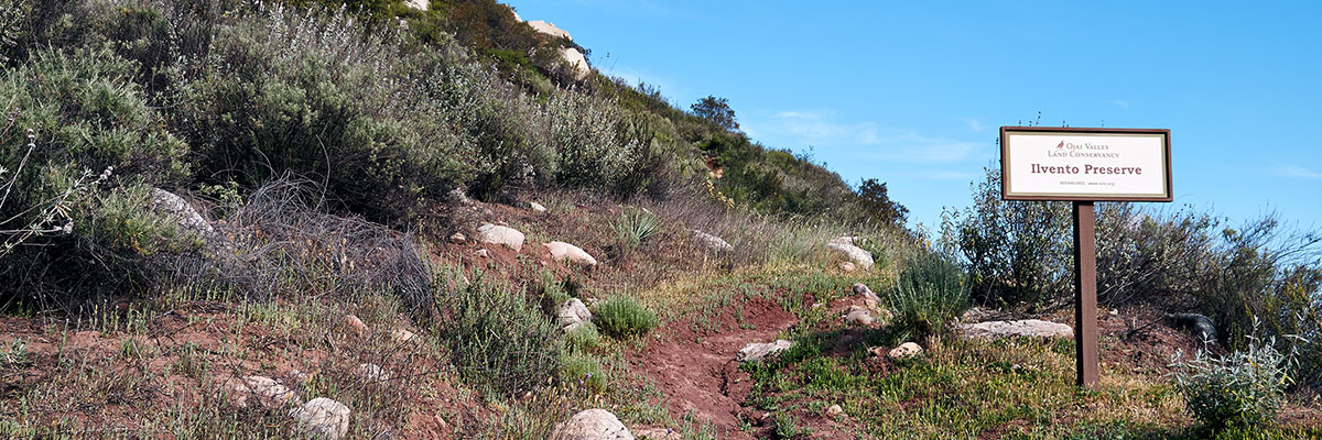
The Ilvento Preserve was the first acquisition by the Ojai Valley Land Conservancy.
Ventura County, Calif. – The Trump Administration is seeking to open nearly 28,000 acres of federal land and mineral estate in the county to fracking and oil drilling, according to an analysis of official GIS data performed by the local nonprofit watchdog organization Los Padres ForestWatch. The areas slated for drilling are part of a regional study – launched earlier this month – evaluating the environmental and public health impacts of fracking across 1.6 million acres in six counties in central California.
The 30-day public comment period ends on September 7.
The study could open several key parcels in Ventura County to drilling and fracking, including the Ojai Valley Land Conservancy’s Ilvento Preserve. This 80-acre parcel was the first land acquisition for OVLC, donated by the Ilvento Family in 1997. Located on a ridge near The Thacher School in the east end of Ojai Valley, the Preserve is host to diverse native plant communities and important wildlife corridors. The parcel is open to the public and features breathtaking views of the Ojai and Upper Ojai valleys, Topa Topa Bluffs, and Chief Peak.
A second parcel that could be opened to drilling and fracking is owned by The Thacher School in Ojai. The 40-acre parcel – located between Thacher and Reeves creeks – is on the eastern edge of campus, and the mineral rights below the parcel are owned by the federal government. The parcel contains a popular hiking trail near the school’s Gymkhana Field where students practice their horsemanship skills and participate in annual competitions and races.
A third privately-owned 40-acre parcel is located between Sisar Canyon and Koenigstein Road in Upper Ojai.
These lands are known as “split estate” parcels because the surface owner is different than the holder of the underlying mineral rights. The BLM did not directly notify the surface owners of the public comment period that is currently underway, and many were unaware of it until ForestWatch requested the data from BLM, analyzed it using mapping software, and notified the property owners.
Under federal law, once its study is complete, the BLM can auction off the drilling rights to these parcels for as little as $2.00 per acre, possibly giving oil companies the right to construct roads, oil wells, pipelines, and other infrastructure on these privately-owned parcels.
Other areas in the county that the BLM’s plan opens for drilling and fracking include nearly 1,500 acres of federal public land adjacent to and within one mile of the Hopper Mountain National Wildlife Refuge, which serves as the hub for efforts to reintroduce endangered California condors into the wild. Also opened to drilling and fracking are several parcels between Fillmore and Piru, a scattering of parcels on the ridge separating Lake Casitas from Highway 101 along the coast, several parcels in the hillsides behind the City of Ventura, and a small parcel on Boney Mountain in Point Mugu State Park.
“This plan is a direct attack on some of the most iconic landmarks in Ventura County,” said ForestWatch executive director Jeff Kuyper. “Drilling and fracking would irreparably change these places that have been set aside for their outdoor recreation opportunities, wildlife habitat, and scenic views.”
The BLM plan would also open up to drilling and fracking three properties that comprise the Naval Base Ventura County: the Port Hueneme Naval CBC, the Pt. Mugu Naval Base, and all of San Nicolas Island (one of the eight Channel Islands located offshore Ventura County).
ForestWatch has posted the BLM’s GIS data on an easy-to-use interactive map showing the parcels open for drilling and fracking. Numerous requests from conservation groups prompted BLM to make the information publicly available during the comment period.
The BLM is accepting comments on its study of drilling and fracking until September 7. The public can submit comments to BLM via an easy on-line portal at www.LPFW.org/fracking or directly through the BLM’s website.
“Central California residents are concerned about the impacts of drilling and fracking near our region’s most treasured forests, wildlife refuges, national monuments, nature preserves, and trails,” said Kuyper. “We need to tell the Trump Administration loud and clear that we’re not willing to pollute and industrialize these iconic landscapes.”
Background
On August 8, 2018, the Trump Administration launched a 30-day public comment period on a study of environmental and public health impacts of hydraulic fracking in central California. The move is the first step in a process that will decide whether to allow the controversial oil extraction technique across 1.6 million acres of federal public land and mineral rights in Santa Barbara, Ventura, San Luis Obispo, Kern, and neighboring counties.
Along with the Federal Register notice, the BLM published a blurry map showing which parcels could be opened to drilling and fracking. The poor quality of the map prompted ForestWatch and its partner the Center for Biological Diversity to request access to the GIS parcel data that BLM used to produce the map. The BLM provided that data to us on August 21, nearly two weeks after receiving the requests and halfway into the public comment period.
The drilling and fracking study was prompted by a 2015 lawsuit filed by Los Padres ForestWatch and the Center for Biological Diversity, represented by Earthjustice. The lawsuit alleged that the Bureau of Land Management (“BLM”) failed to consider the impacts of fracking as part of the BLM’s update of its Resource Management Plan for federal lands within the jurisdiction of the agency’s Bakersfield Field Office.
The groups prevailed in 2016 when a federal court ruled that BLM failed to adequately analyze the impacts of fracking across vast swaths of public land in the region. The U.S. District Court for the Central District of California, based in Los Angeles, ordered the agency to evaluate those impacts in a supplemental Environmental Impact Statement. In a settlement agreement with ForestWatch and the Center, the BLM agreed to not issue any new leases for oil drilling in the region until the supplemental report is complete.
The 30-day comment period begins that process. At the conclusion of the analysis, the BLM may consider amending its management plan to impose additional restrictions on fracking that would apply on some or all of the 1.6 million acres of land currently open for new oil leasing.
The analysis covers 400,000 acres of federal land and an additional 1.2 million acres of federal mineral estate, including thousands of acres adjacent to the Los Padres National Forest, Carrizo Plain National Monument, Hopper Mountain and Bitter Creek National Wildlife Refuges, and the Wind Wolves Preserve.
Hydraulic fracturing – commonly known as “fracking” – is a process whereby water, sand, and thousands of gallons of chemical additives are injected underground to break apart rock formations and stimulate the extraction of oil and gas. The technique has come under increasing scrutiny from scientists, regulators, and the public due to concerns with groundwater contamination, surface water pollution, water consumption, and public health. Hundreds of fracking chemicals are known to be toxic to humans and wildlife, and several are known to cause cancer, according to several peer-reviewed studies by scientists and state regulators. A 2015 report from the California Council on Science and Technology highlighted these risks.
A shocking and sobering situation. Thank you so much for making this information known. I hope many, many people will take the time to voice their concerns to the BLM.
Absolutely no fracking. This must be stopped the same way the Wheeler Canyon dump and rock quarry trucking through town was stopped. Ojai will unite and resist. Nooooooooooooo